~ Similarities with recent years may be few
~Very late Arctic Basin High to Low pressure switchover is expected
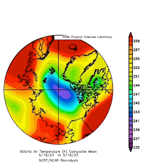
April-May

Clouds domination affect two primary weather parameters, one is snow on the surface, two is apparent slow melting of sea ice. In other words, an apparent cooling will be the result, building cold High pressure systems, which become stable over the Arctic basin Gyre until a switchover occurs, this when cold surface air is part of a summer Low pressure system. There should be a High pressure system dominating most days over the Arctic Basin Gyre throughout this period. The extra snow is a proxy for sea ice, it is not as stable as sea ice, from snow sublimation and under sea ice warmer water temperatures. The thinner sea ice area come June and July, bereft of snow, will likely maintain a summer High pressure system, favoring warmer air. Thereafter, when the ice melts, open Polar cooler ocean becomes the main main attraction for Arctic summer cyclones, so switchover is expected in late July primarily because winter heat imprint on sea ice on the Canadian side of the Pole is far stronger than on the Russian side. This late switch in pressure system locations would have been much earlier given a CTNP dominances on the Canadian side, that was not the case. A double H high pressure symbol, from blue to war red, indicates the evolution of the nature of anticyclones when spring turns to summer. The cold nights and low noon sun of spring favors High’s being cold, eventually the sun gaining height in the sky literally changes the nature of pressure systems. A Blue High indicates a stable much slower transition, like wise with cyclones which are usually always cooler in summer, but except for in origin warm sea cyclones, including intense hurricanes.
June-July

The Arctic basin Gyre will be blasted by more sun rays than usual on account of a late pressure switchover, at about mid July onwards the extreme sun bath slows down. Desert High Pressures will expand in extent Northwards in both America and from North Africa. The Lone CTNP cell will hang about Russia, apparently causing a delay in ice melting there. The Polar jet stream will collapse in pieces but along near this cell. Cold surface hugging cyclones will dominate wherever open water subsists, one must remember the effects of El-Nino worldwide extra clouds on creating extra precipitation, making their final disruptions, mid west North America late July onwards. The dissolution of the CTNP will finally entail a strong late melting rate on the Russian side of the Pole,
August-September

Unfortunately, predicting that there will be another great sea ice melt is easy, its final form, extent and where it melts not so. Eventually as August progresses Greenland takes prominence as the only Mega albedo area in the Arctic, it should become the CTNP, but its altitude prevents this, however remnant Arctic Basin sea ice will team up with Greenland to form the new Polar Vortex of sorts, hence a zone of High pressures to the North and Southwards of Greenland will be encroached by slow moving cyclones. East of Greenland median cyclones often to become quasi stationary over open vast open sea water areas. To the West of Greenland median ever so inching Northwards cyclones appear to struggle moving North by Synoptic weather systems. Western Europe and Central North America will have significant slow moving High Pressures not part of the desert anticyclones further Southwards. As El’Nino does not usually foster numerous hurricanes , the few will be caught from being quasi stationary by the elongated Greenland Southern High pressure, ensuring slow rotational death at sea in the East Atlantic, or slow encroachment Northwards joining the Eastern North American seaboard. Not like typhoons venturing further North than ever thought possible. The biggest problem for a complete Arctic sea ice melt will continue, mainly by two factors; waning El-Nino twinned with the ever so persisting North Pacific surface sea water high temperature blob, a perpetual cloud machine. I’d expect a greater melt than 2012 but not by much, Arctic basin sea ice remnants at minima will look awfully battered and emaciated though. Freeze-up in October will permeate the Arctic Ocean shores with even more fast ice extending much larger than October 2023. If the Arctic Ocean winter come December looks like a dark ring of thin ice throughout the entire inner Sea, 2025 melt will finally clear at the Pole. It was amazing to witness thick pack sea ice not overpowering the much thinner NW Canadian archipelago expansive dark fast ice all winter. The end of summer sea ice is nigh within a few years if this dark ring occurs. In the mean time, Canadian side 2024 Northwest passage will open first before the Russian North East one, however the broken ice from the larger Basin will clog channels up for a while.
Over all weather is what you’d expect from the last few years except for the greater moisture impact El-Nino gives, a tandem dynamic effect in the Polar regions was and is a significant CTNP shift towards Russia, it is very unlikely that weather in most parts of the Northern Hemisphere will be the same as Summer 2023. Rather the only thing similar is the slow sluggish movement of weather systems, obviously under more rainy conditions, that is a key difference , but not where massive anticyclones hardly move. For some celebrate during great sunny weather days, for others too much every day solar heat than desired induces Air Conditioning isolation inside the smaller world home, too much of any weather feature is never pleasant. The consequences of slow moving pressure systems give simultaneous extreme weather differences within the same continents, ‘extreme lack of familiar weather’ will be key often repeated words surely to be used.

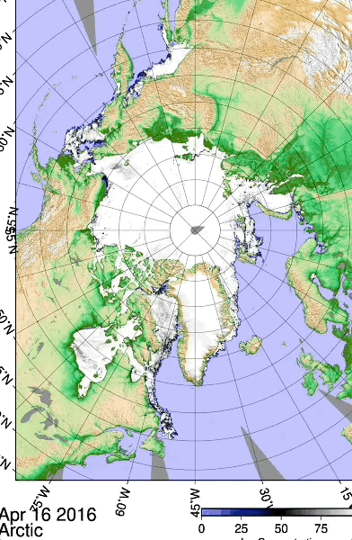
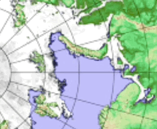
Extraordinary Polarview central Northwest coast of the Canadian Arctic Archipelago black fast ice (2024/02/18), fast ice is first year ice while the white ones are multiyears), stayed like so the entire winter, while in a few years past would have been easily crushed when first formed in late autumn.